
Aerial Monitoring of Landfill Methane
Using airborne modern technology to find methane leaks
The Problem: Super Emitters are Being Missed
Many landfill methane emissions go undetected under current regulatory monitoring systems. The federal Method 21 for surface emission monitoring (SEM) requires technicians to walk the landfill surface with handheld methane sensors in a grid pattern. While this approach can identify leaks in specific locations, it often misses major emission sources across the landfill site. Remote sensing studies using aircraft and satellites have repeatedly identified methane plumes from landfills, with roughly 40% of plume events traced to previously unidentified, repairable leaks. These findings reveal a major gap: significant emissions are happening outside the reach of traditional monitoring, and many could be fixed if they were detected in time.
Technology has advanced rapidly, but federal regulations have not kept pace with these capabilities. Satellites and aerial surveys can now detect large methane plumes across entire landfill sites - including areas that are unsafe or impractical to monitor on foot- and provide near real-time information about major leaks. Existing federal rules are still built around periodic, manual inspections and are largely silent on how to use remotely detected methane data, meaning that even when large emissions are identified, there is often no clear requirement to act.
A few leading states are beginning to close this gap: Colorado, for example, moved to explicitly incorporate satellite and aerial plume detection into its landfill methane rules, including requirements that operators investigate and repair leaks when notified of remotely detected emissions. These emerging state policies recognize a fundamental shift: methane detection is no longer limited by where a person can walk, and regulations must evolve to ensure that new data actually drives real-world emissions reductions.
Because current manual monitoring occurs only periodically and at limited locations, leaks can persist for months or years before they are discovered and repaired. As the images below illustrate, it’s hard to find an invisible leak across a massive landfill. Without a clear signal showing where to look, even large emissions can remain hidden in plain sight.

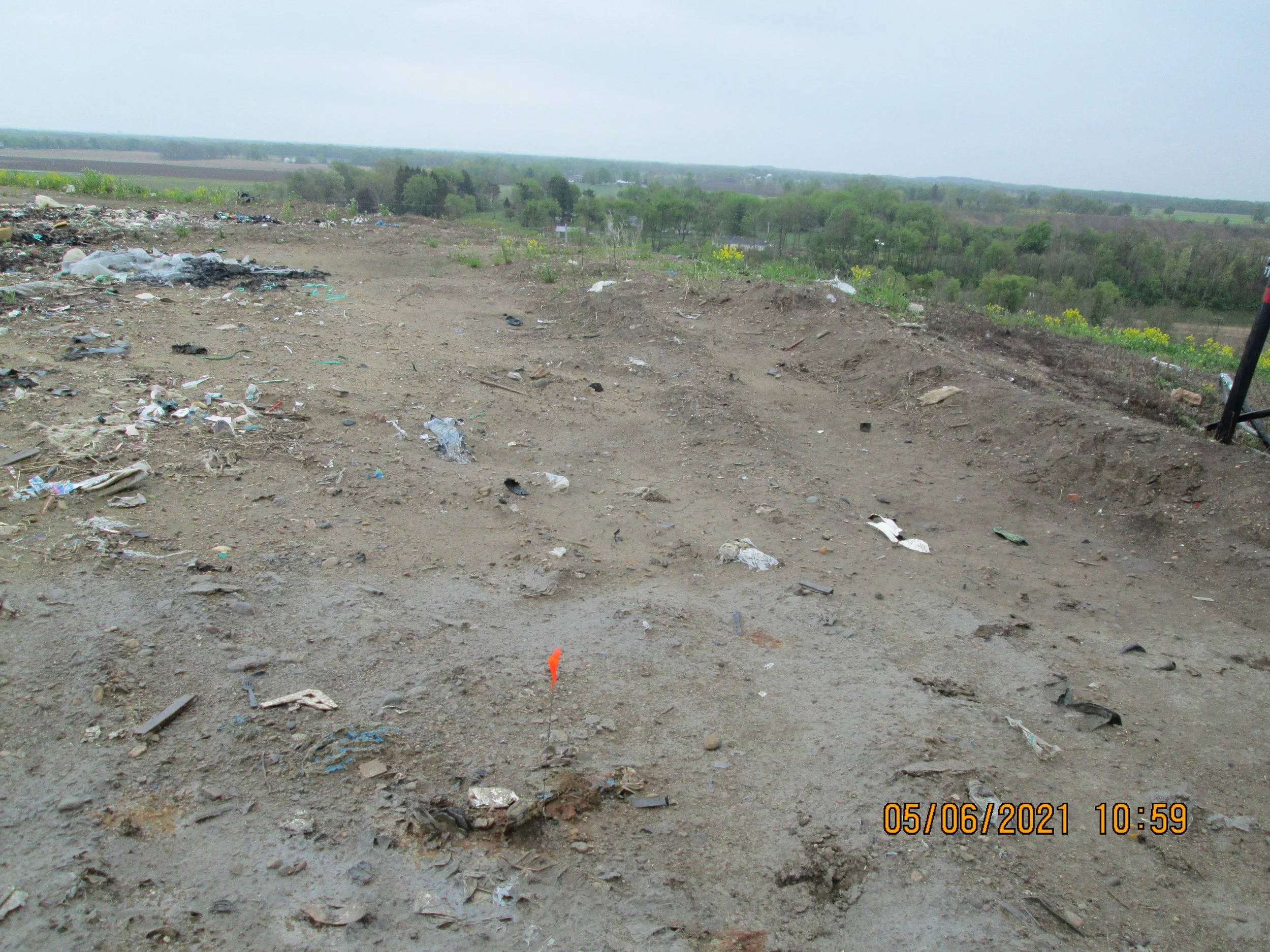
Images from EPA inspection of the Southeast Berrien County Landfill in Buchanan, Michigan. Red flags indicate methane exceedances, which are invisible to the naked eye.
The Fix
Aerial technologies such as satellites are transforming methane detection from a slow, manual search to precise, actionable intelligence. Instead of relying on technicians to walk hundreds of acres hoping to encounter a leak, regulators can now see the largest emission sources from space and direct operators exactly where to go. This is a fundamental shift: from searching for a needle in a haystack to being handed a map of the biggest leaks. By focusing attention on these high-emitting “super emitters,” policymakers have an unprecedented opportunity to drive faster, more effective emissions reductions.
States should require that the landfill operator respond to detections of large methane plumes from methane monitoring technologies that have been approved by the regulator, such as aerial surveys or satellites. The operator should correct exceedances found, and this information should be accessible to the public.
Timely and effective detection of large methane emissions through satellite or airflights remote flyovers holds the potential for exponentially more effective methane mitigation.
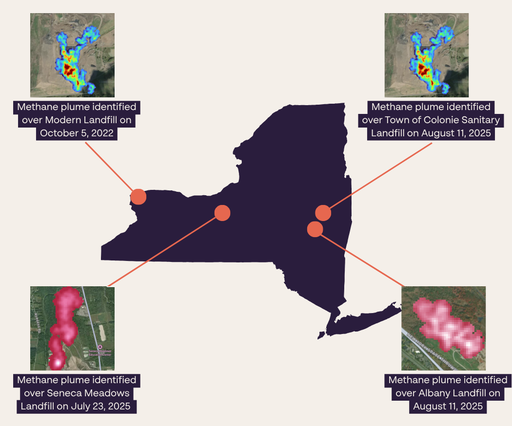
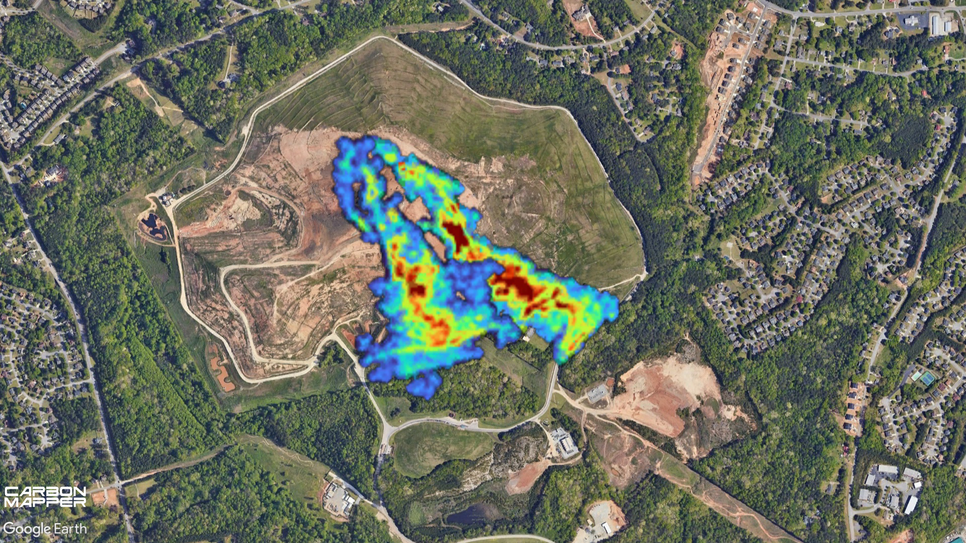
Examples of methane plumes observed at New York landfills
Key Model Rule Elements: Integrating Satellite and Remote Methane Detection
-
Satellite and aircraft methane detection should be integrated into landfill regulations as a complement, not a replacement, for surface emissions monitoring (SEM). Remote sensing technologies can quickly scan entire landfill sites, identify the largest plumes, and detect emissions from areas that may be missed by quarterly walking surveys, such as the working face or hard-to-access slopes. When paired with ground-based inspections, this creates a more complete monitoring system capable of detecting emissions sooner and directing operators to the most likely leak locations.
-
When remote sensing identifies a methane plume, rules should require landfill operators to investigate and report back with specific contextual information. This should include whether the area was previously monitored during SEM surveys, whether elevated methane had been detected there before, likely emission sources, recent site activities (such as waste placement or cover installation), and operational data such as wellhead pressures or flare downtime. These details help regulators determine whether emissions stem from temporary operations, gas collection problems, or persistent leaks that require corrective action.
-
Regulations should require that remote sensing technologies demonstrate reliable methane detection capability, but they should not restrict approval to a single validation pathway. Because controlled-release testing for landfill emissions is still limited, rules should allow validation through a combination of methods, including inter-comparison with other monitoring technologies and confirmation of emissions through follow-up field measurements.
-
The active working face of landfills is a major source of methane emissions and should be explicitly addressed in monitoring rules. Remote sensing technologies are particularly valuable here because traditional walking surveys often cannot safely or effectively measure emissions in these areas. Monitoring the working face can help operators identify operational practices that lead to large emissions and improve gas capture over time.
-
Data from remote methane detections and follow-up investigations should be publicly available. Regulators should publish landfill-specific detection data, operator responses, corrective actions, and resolution timelines through accessible dashboards or periodic reports.
Examples from Leading States
Colorado, Regulation 31, 2025: Requires landfill operators to quickly investigate, address, and report back on large methane releases once they are notified.
It ensures credibility by requiring third parties providing these notifications to be certified by EPA or the state.
It clearly lays out required corrective actions, setting expectations for both landfill operators and the public.
Repeated large releases (above 207 kg/hr) trigger a requirement to install a gas collection system if one is not already in place, unless tied to approved activities like excavation. This threshold is reasonable because it reflects emissions levels that would already warrant controls under standard calculations.
The rule also requires detailed reporting on plume detections, including the detection method, plume visualization, and estimated release rate.
California, LMR 2025: Institutes a Remote Emission Plume Response requirement, when a methane plume is detected by satellite or aerial monitoring:
The landfill operator must inspect a defined area (600 ft × 600 ft) around the plume source.
They must conduct surface emissions monitoring (SEM) and component leak monitoring within 5 days.
This inspection is essentially the same procedure already used for quarterly compliance monitoring using manual technologies, just triggered by a plume alert.
Provides data and results to the public.
Costs and Benefits
Costs to landfills is essentially conducting an additional surface emissions monitoring inspection, following up on what the 3rd party has already detected. Because the plume response rule inspects only a small area (600 × 600 ft) rather than the entire landfill, the cost of a plume response inspection is much smaller than a full SEM survey.
Resource Spotlight: Hunting Methane Using Satellites
This guide gives policymakers a practical roadmap for using satellite data to strengthen methane oversight. It shows how remote sensing can improve emissions inventories, find large leaks faster, and support notification-and-response programs, while also making clear that satellites should complement—not replace—ground-based monitoring and other enforcement tools.